
Guest post by Maggie Church, 2025-2026 Sustainability Leadership Fellow and PhD Student in the Department of Ecosystem Science and Sustainability and Graduate Degree Program in Ecology
Wetlands have always been easy to overlook. For much of American history, wetlands have been thought of as little more than stinky, mosquito-filled obstacles – something to drain and replace. Cultural references haven’t helped: imagine Shrek’s swamp, or Frodo’s journey through the Dead Marshes. Many people, including myself, rarely gave wetlands a thought. But then I started a PhD project focused on wetlands and learned to see them differently.
Some Potholes are Good
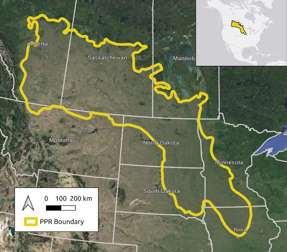
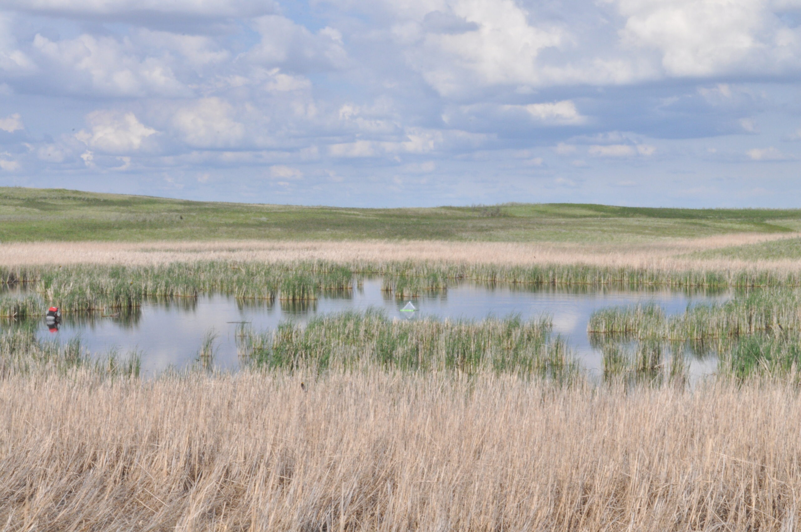
Did you know there’s a wetland complex in North America roughly the size of Texas? It’s called the Prairie Pothole Region (PPR). In this region, millions of shallow, glacier-carved “potholes” are scattered across the farms and grasslands of the Great Plains. They may look small and isolated, but together they create one of the largest wetland systems in the world. In fact, the PPR contains so many wetland resources that 50-80% of all North American ducks nest here. These wetlands also filter and prevent fertilizers from reaching downstream waters, absorb floodwater, recharge groundwater, store carbon, and support other threatened species.
The Role of Maps
The fact that wetlands have been overlooked isn’t just a cultural blind spot, it’s a data problem. Traditionally, wetlands have been mapped through manual inventories like field surveys or aerial imagery, requiring field teams to trudge through mud, or fly expensive planes. While incredibly useful, these efforts provide only static snapshots in time. But wetlands aren’t static, especially in the PPR, where a basin may be full of water one week and dry the next. Simply knowing where wetlands exist is important, but we also need to know when they contain water, because timing drives everything in the ecosystems, from duck settling to flood modeling.
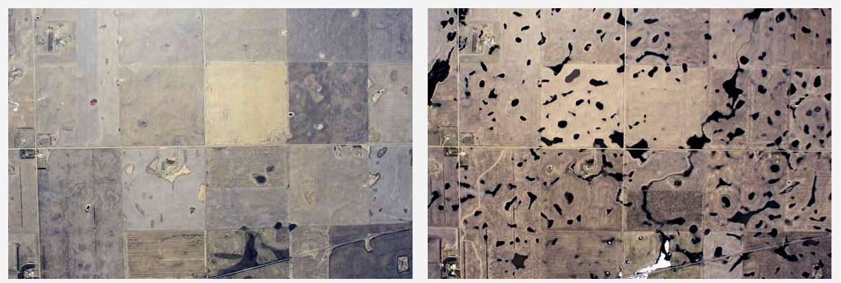
With the advent of satellite imaging, we can now track water dynamics across the PPR near-continuously from space. This process, called remote sensing, is what I focus on in my work. But remote sensing also has its limitations: while satellites are good at finding large, open waterbodies, most wetlands in the PPR are small and often go undetected.
This gap matters because small wetlands are of particular conservation concern – they are both highly vulnerable to drainage and uniquely valuable:
- Early-season habitat: Right now, ducks arriving in the PPR are foraging in small ponds because they are first to thaw and teem with invertebrates, providing the protein required for breeding
- Flood reduction: The PPR has been in a wet period since 1993, and many large wetlands are at their water-storage capacity. Meanwhile, small wetlands can more effectively cycle water into plants, groundwater, and the atmosphere, leaving them better able to absorb additional water.
- Nutrient removal: With their high contact between water and sediments, small wetlands are hotspots of nutrient removal (wetlands < 325 m2 account for more than half of water-based nitrogen removal).
To guide conservation and inform policy, we need a more complete picture – one that includes all wetlands. In their 2017 Nature paper (which I highly recommend), Creed et al. describe vulnerable wetlands such as potholes as “frequently unmapped and poorly protected, and are hence susceptible to degradation or destruction.” In other words, when wetlands are missing from maps, they remain vulnerable. This is the problem my colleagues and I are working to address.
We built a tool called the Prairie Pothole Mapper, which uses extensive aerial surveys to train a model to detect water from satellite imagery. This free, open source tool can detect two-thirds of waterbodies, outperforming existing methods which only detect 35-50%. Critically, our mapping improves the visibility of the PPR’s uniquely valuable small waterbodies. We are now working to detect the remaining third by using new types of satellites, like radar, to reveal the wetlands hidden beneath clouds and vegetation.
Under pressure
Conservation in this region is more important now than ever. Over half of wetland area in the United States had been lost since European settlement. In November, the EPA moved to remove Clean Water Act protections for roughly 85% of remaining wetlands, and nearly all wetlands in the PPR. Without this safeguard, economic pressures from high crop prices and growing food demand may put PPR wetlands at heightened risk of drainage and conversion to row crops.
I came to study wetlands by chance, but spending the past few years mapping prairie potholes has changed how I see the Great Plains. It’s not just endless fields of corn and soy. It’s rolling hills with patches of wetlands and native grasses – an interconnected system of wetlands acting like capillaries, keeping our nation’s breadbasket functioning properly while sustaining wildlife. The latest Clean Water Act revisions assume individual potholes have negligible impacts on waterways, but scientists understand that together they confer watershed resilience. Wetlands are often overlooked, but they are essential, and it is time they are brought into focus.